Dictionary of Fairfax Biography

Items

Louisa Ferguson Property -- Exact Location
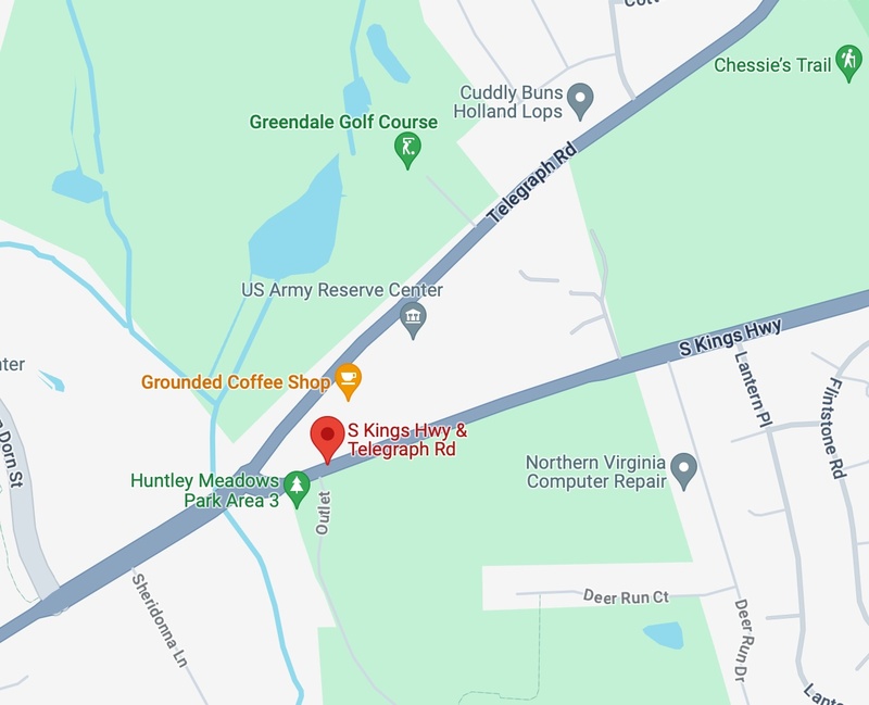
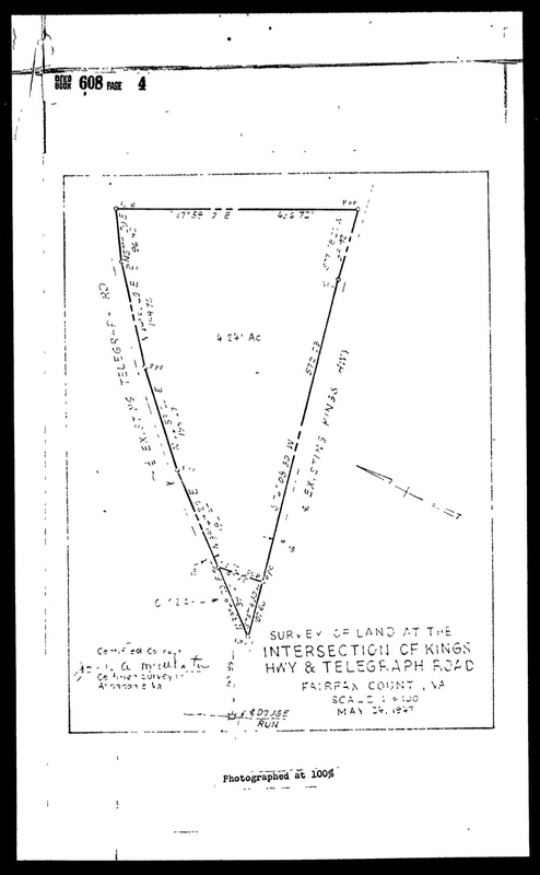
This Google Maps image is the exact location where the Louisa Ferguson property was located. This information was found via the 1948 Ferguson - Davis land deed, which features a diagram of the property and the intersection at which it was located (Telegraph Road and South Kings Highway). The land is now home to a US Army Reserve Center and coffee shop, among other things.
Woodlawn Colored School
Originally called the Accotink school, it was located to what is known today as Fort Belvoir.
WHC 1900 US Census
WHC 1900 US Census
This is a page from the 1900 US Census (incl. William H. Carter denoted as Wm H Carter") with details pertaining to his person, birthplace, his occupation, and his current household members. Of note, not included is "Mary Carter".
WHC 1870 United States Federal Census
This is a page from the 1870 US Federal Census (incl. "William H Carter") with details pertaining to his birthplace, home residence, parents, and if he attended school.
Louisa Ferguson Property Diagram
This page, showing a diagram of Louisa Ferguson's Telegraph Road property, is from the 1948 Ferguson - Davis land deed document. It shows measurements of the land and acreage.
Telegraph Road
Telegraph Road
This Google Maps image shows Telegraph Road in the Mount Vernon district, which Louisa Ferguson's property rested on.
Eliza A. Ford - Hensley Court Development
Pictured is the development plan for Hensley Court, which is the property that previously belonged to Eliza A. Ford.
Eliza A. Ford - Chancery Case
Pictured is the first page of the Chancery Case involving the property belonging to the Eliza Ford Estate
Eliza A. Ford Land Tax Records 1964
Pictured is the 1964 Land Tax Records for the Mt. Vernon District in Fairfax County (Land Plat No. 21 Displayed)
GIS of Fairfax County 1980 - Eliza A. Ford
This image displays an outline of Eliza A. Ford's property in 1980. The information for the land area was determined using the Tax Map Grid square 102-3 which was found in the Land Tax Records Book in 1960 and 1980 respectively.
GIS of Fairfax County 1960 - Eliza A. Ford
This image displays an outline of Eliza A. Ford's property in 1960. The information for the land area was determined using the Tax Map Grid square 102-3 which was found in the Land Tax Records Book in 1960.
Gum Spring Together
Gum Spring Together
The people of Gum Spring, united no matter the differences
History of Gum Spring
The Gum Springs welcome sign, established in 1833 by the community.
John Brown Tax Records- After
John Brown’s Tax Records in 1922. His name is not present from this point on.
John Brown Tax Records- Before
John Brown Tax Records in 1921. Highlighted shows John Brown is present
John Brown Gains Land- Deed Index
The deed index shows John got a trust (mortgage) for his land
John Brown Gains Land- Deed
The deeds of John Brown’s land, which was sold in 1908. The names include William Dandridge Smith, Annie M. Smith, Mary E. Brooks, and John Brown himself.

John Gains Land- Witnesses
The witnessing of the land being sold. Witnesses: Mary E. Brooks, Elizabeth E. Gordon, and John A. Brown.
John's Living Areas
John's Living Areas
John Brown’s main areas he lived: in Tazewell, Richmond, and Big Creek in West Virginia.
1894 Q-5-P692 Deed
1894 Q-5-P692 Deed
The county took ownership of Andrew Lee's property due to his failure to pay taxes.
1890 I-5-P523 Deed
1890 I-5-P523 Deed
Deed between Lovelace and Emily Brown and Andrew Lee on 25th of February, 1890
John and Julia’s Marriage Record
John and Julia’s marriage record, recorded in 1910
The Man in Gum Spring
A man sitting during Gum Spring’s early days.
Map of west Mount Vernon
Andrew Lee Death Newspaper
Andrew Lee found dead in 1892 due to fire in house. He couldn't escape the house because of grip (Influenza). He was found by his wife