-
 Louisa Ferguson Property -- Exact Location
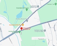
 This Google Maps image is the exact location where the Louisa Ferguson property was located. This information was found via the 1948 Ferguson - Davis land deed, which features a diagram of the property and the intersection at which it was located (Telegraph Road and South Kings Highway). The land is now home to a US Army Reserve Center and coffee shop, among other things.
-
 Woodlawn Colored School
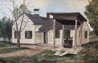
 Originally called the Accotink school, it was located to what is known today as Fort Belvoir.
-
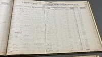
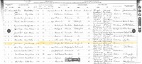
 WHC 1900 US Census
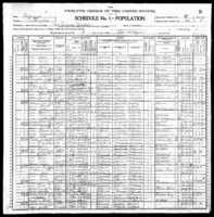
 This is a page from the 1900 US Census (incl. William H. Carter denoted as Wm H Carter") with details pertaining to his person, birthplace, his occupation, and his current household members. Of note, not included is "Mary Carter".
-
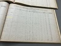
 WHC 1870 United States Federal Census
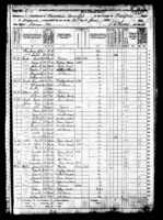
 This is a page from the 1870 US Federal Census (incl. "William H Carter") with details pertaining to his birthplace, home residence, parents, and if he attended school.
-
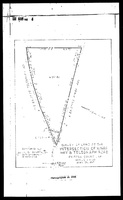 Louisa Ferguson Property Diagram
 This page, showing a diagram of Louisa Ferguson's Telegraph Road property, is from the 1948 Ferguson - Davis land deed document. It shows measurements of the land and acreage.
-
 Telegraph Road
 This Google Maps image shows Telegraph Road in the Mount Vernon district, which Louisa Ferguson's property rested on.
-
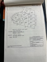 Eliza A. Ford - Hensley Court Development
 Pictured is the development plan for Hensley Court, which is the property that previously belonged to Eliza A. Ford.
-
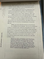 Eliza A. Ford - Chancery Case
 Pictured is the first page of the Chancery Case involving the property belonging to the Eliza Ford Estate
-
 Eliza A. Ford Land Tax Records 1964
 Pictured is the 1964 Land Tax Records for the Mt. Vernon District in Fairfax County (Land Plat No. 21 Displayed)
-
 GIS of Fairfax County 1980 - Eliza A. Ford
 This image displays an outline of Eliza A. Ford's property in 1980. The information for the land area was determined using the Tax Map Grid square 102-3 which was found in the Land Tax Records Book in 1960 and 1980 respectively.
-
 GIS of Fairfax County 1960 - Eliza A. Ford
 This image displays an outline of Eliza A. Ford's property in 1960. The information for the land area was determined using the Tax Map Grid square 102-3 which was found in the Land Tax Records Book in 1960.
-
 Gum Spring Together
 The people of Gum Spring, united no matter the differences
-
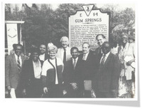
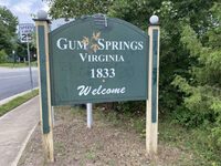 History of Gum Spring
 The Gum Springs welcome sign, established in 1833 by the community.
-
 John Brown Tax Records- After
 John Brown’s Tax Records in 1922. His name is not present from this point on.
-
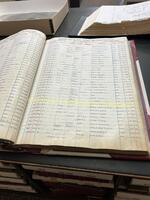
 John Brown Tax Records- Before
 John Brown Tax Records in 1921. Highlighted shows John Brown is present
-
 John Brown Gains Land- Deed Index
 The deed index shows John got a trust (mortgage) for his land
-
 John Brown Gains Land- Deed
 The deeds of John Brown’s land, which was sold in 1908. The names include William Dandridge Smith, Annie M. Smith, Mary E. Brooks, and John Brown himself.
-
 John Gains Land- Witnesses
 The witnessing of the land being sold. Witnesses: Mary E. Brooks, Elizabeth E. Gordon, and John A. Brown.
-
 John's Living Areas
 John Brown’s main areas he lived: in Tazewell, Richmond, and Big Creek in West Virginia.
-
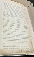
 1894 Q-5-P692 Deed
 The county took ownership of Andrew Lee's property due to his failure to pay taxes.
-
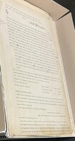
 1890 I-5-P523 Deed
 Deed between Lovelace and Emily Brown and Andrew Lee on 25th of February, 1890
-
 John and Julia’s Marriage Record
 John and Julia’s marriage record, recorded in 1910
-
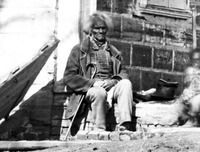 The Man in Gum Spring
 A man sitting during Gum Spring’s early days.
-
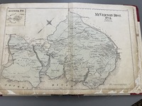 Map of west Mount Vernon
 Map of west Mount Vernon
-
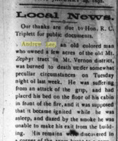 Andrew Lee Death Newspaper
 Andrew Lee found dead in 1892 due to fire in house. He couldn't escape the house because of grip (Influenza). He was found by his wife