George Carroll
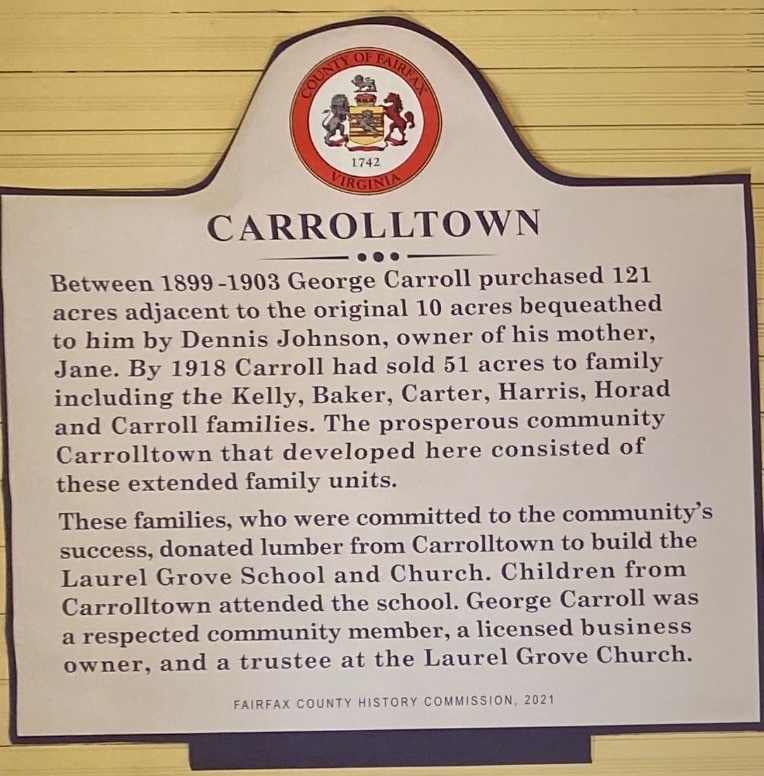
Carrolltown Land Marker
The land marker details Carrolltown as a small community spanning over 121 acres which George Carroll had purchased in the span of his lifetime. The sign also states that George made a huge contribution to the developments of Laurel Grove School and Church by donating lumbar.
George Carroll, an African American landowner during the late nineteenth and early twentieth centuries, resided in Fairfax County, Virginia. This presentation contributes to the Black Lives Next Door initiative at George Mason University, supported by the Center for Mason Legacies. The exhibit intends to construct a biography of Carroll's life through interpreting limited evidence and the use of scholarly research methods.
In our exploration of black land ownership, insights from the Fairfax County Circuit Court’s Historic Records Center and the Virginia Room of the Fairfax County Public Library proved invaluable. Inspired by scholars like Fuentes, we adopted a nuanced historical approach, rooted in the perspective of enslaved individuals. Fuentes' methodology unveils the layers of complexity defining their existence, capturing both the brutality of bondage and the subtle acts of resistance and resilience inherent in the human experience [2].
Our journey began with land tax records, segregating ownership by race from 1891. The 1894 Mount Vernon District "Table of Tracts of Land '' provided a scanned insight into Carroll's contributions, revealing details such as the landowner's name, acreage, location, and taxes paid. This research allowed us to trace the trajectory of George Carroll's life, unraveling it through the lens of tax payments on his property, from the earliest to the latest instances. This exploration sheds light on the life he led and the broader context within the Mount Vernon District, specifically examined near Telegraph road, Virginia. Through interpretations of maps, census/cemetery records, and book scholars such as Casper Scott and Nan Netherton, the life of Carroll is captured with appreciation to Fairfax history. The presentation will begin with the 1894 Land Tax Records displayed below.
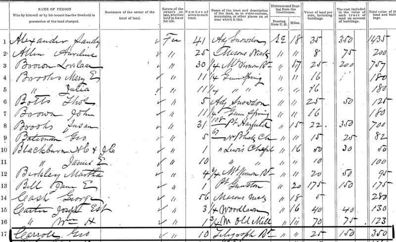
1894 Land Tax Records: Fairfax County Circuit Court -- George Carroll
In the 1894 Land Tax Mount Vernon Record, name of the land owners, location, acreage, and land value. George Carroll is listed under the name Geo for short (shown in the black box).
In the 1894 Land Tax Records, George Carroll (indicated in black) signed using his nickname Geo. The document reveals that George possessed 10 acres of land situated by Telegraph Road, appraised at a total value of $350, encompassing both the land and its structures. Examining the documented evidence of George's land ownership provides vital clues for unraveling the details of his life, particularly through the markers of land acreage and the proximity to Telegraph Road.
[1]Fairfax County Land Tax Records, 1897, “Table of Tracts of Lands for the Year 1894, Fairfax County, Mount Vernon District, Colored,” Fairfax County Circuit Court, Historic Records Center, 55-57.
[2] Fuentes, Marisa J. Dispossessed Lives : Enslaved Women, Violence, and the Archive. Philadelphia: University of Pennsylvania Press, 2016. Print.
[3]“Laurel Grove School Museum.” Fairfax County African American History Inventory, fairfaxaahi.centerformasonslegacies.com/items/show/13. Accessed 1 Dec. 2023.