
Establishing Communities
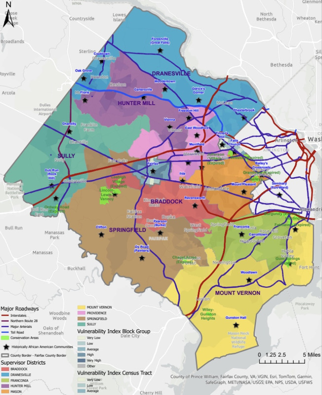
Map of historic African American communities in Fairfax.
Historical records show racialized zoning emerging in Fairfax began in the 1880s, spurred by alarm over expanding Black property ownership and political power. In the late 1800s, mobility and economic ambition drew emancipated African Americans north to communities across Fairfax, a once-and-future agricultural powerhouse, where, due to the ravages of civil war, land had become affordable. Their arrival, along with the enterprise of longtime, formerly enslaved locals, drove the emergence of independent Black communities in localities like Ilda, Lincolnia, Jermantown, Queen City (located next to today’s Pentagon) and The Pines, near Merrifield; in farm enclaves on property that once belonged to George Washington and his neighbors at Gum Springs and Woodlawn; in west-county hamlets like Cooktown and Lincoln-Lewis Vanoy and Cub Run; around School Street near and beneath the present-day property of George Mason University; and in villages and neighborhoods all across the county. From the end of the Civil War, Black people asserted claims on Fairfax County land. Many of these newly autonomous residents leased and acquired town properties, farmland, and homes. Their investments promised generational wealth and reduced Black dependence on the White community while advancing African American autonomy.
After the Civil War, despite challenges in establishing themselves as citizens, Black Americans in Fairfax strove to acquire property as a tangible expression of their newfound freedom. That they managed to do so in significant numbers, controlling thousands of acres by 1900, testifies to their resilience and determination. The emergence of Falls Church’s relatively affluent Black enclave of Tinner Hill provides one illustration of how collective and generational fortitude enabled these successes—and also how they could be imperiled by official actions.
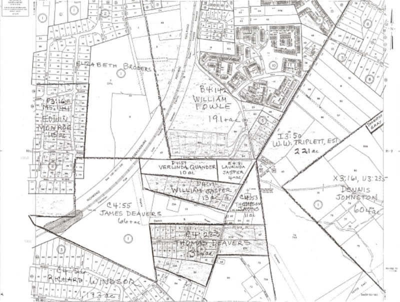
1860 property map demonstrates local Black property ownership predates the Civil War. County records show that sixty-six African Americans owned Fairfax land that year, including, as shown here, William Jasper (13 acres), Thornton Gray (5 acres), and at least two women, Laurinda Jasper (10 acres) and Verlinda Quander (4 acres).
On December 27, 1866, James Lee and his brother Charles purchased eight acres of land in the Southgate subdivision for $400. This transaction marked a significant moment in Black property ownership history in Fairfax County. A White land speculator named M.E. Church sold parcels of land to the Lee brothers marking the origins of the Southgate subdivision. The subdivision consisted of narrow lots running parallel to Liberty and Douglas Streets, with boundaries extending from Hillwood Avenue to Arlington Boulevard. Southgate remains a predominantly Black community, a lasting testament to the pioneering efforts of the Lee brothers.
Certain White property owners’ willingness (or need) to sell acreage to Black buyers enabled numerous hamlets and villages to sprout across rural Fairfax. By the 1880s, African Americans were migrating to communities of color like the Lees’ “Hill” as well as Gravel Banks, Southgate, other parts of Falls Church, Woodlawn, near Mount Vernon, and Merrifield, where Union veteran Robert Porter helped put several Black names on farm deeds.