Black Neighborhoods in Arlington
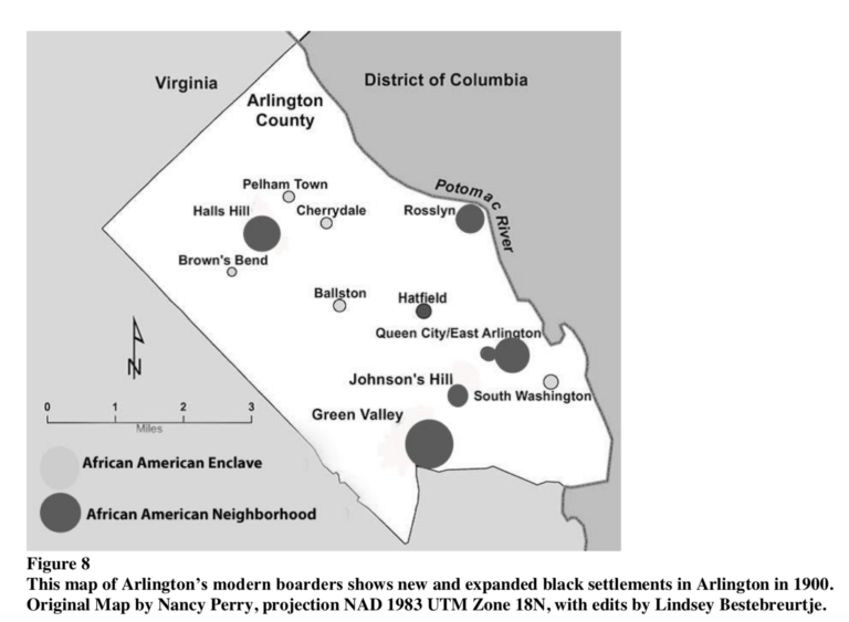
This section of Black Land Matters aims to focus on the development of segregated neighborhoods for Black people and their legacy across time.
- Subject of Research
-
Arlington County Fire Station No. 8 (Current)
Halls Hill/High View Park Volunteer Fire Department (Historic) - Story
-
In 1918, residents of Halls Hill, as High View Park was known at the turn of the twentieth century, established the Halls Hill Volunteer (Fire Department #8) (Walk Arlington 2014; Maas et. Al 2017: 60; Simon 2018; Jones 2018: 16-17). Fire Station #8 was the County’s first African American-manned fire station created during a segregated era when African American communities across the nation created autonomous social, civic, religious, commercial and residential enclaves throughout the nation (ACCB 1994; Simon 2018). The fire department elected its first officers in 1925 with C.H. Chinn as its chief along with volunteer officers Robert Nickerson (President), Samuel Taylor (Vice-President), F.W. Ewell (Secretary) and William E. Lewis (Treasurer) and officially incorporated in 1927. Historic research revealed that in 1927, the fire department had its first location along Lee Avenue before relocating to its current area (ACHPP 2016:21). By 1934, the department moved to its current location on property owned by the Hicks family (Golkin 2015; Simon 2018a). The first HHVFD building located at 2209 N. Culpeper Street was adjacent to the William and Susana Hicks residence on Lot 26 of the Cottage Park subdivision (Simon 2018a; Jones 2018: 52)). The building was a simple, two-bay, front-gabled structure with a center-ridge, bell-rigged cupola constructed circa 1934 (Maas et al. 2017: 60).
The rudimentary beginnings of the fire station included a team of six who utilized a two-wheel cart outfitted with a 60-gallon chemical tank to navigate the High View Park neighborhood (ACCB 1994; Walk Arlington 2014; Simon 2018). The Halls Hill community procured the equipment for the fire station during its earliest years through fund-raising carnivals, door-to-door canvassing, and subscription support. By 1926, the force acquired a 1917 Mitchell motor-driven fire truck with a mounted 60-gallon chemical tank/extinguisher. Through continued community support, the fire department continued to upgrade its equipment. In 1933, they acquired a County-provided 1929 Diamond-T fire truck, a 1929 600-gallon pumper in the early 1950s. Unfortunately, County-provided equipment was often used, outdated or faulty (Golkin 2015; Simon 2018:8). In addition, County compensation for the department also lagged. Nevertheless, “Fire Station 8 played a significant role in supporting the residents of Halls Hill during the war [World War II (WWII)]. Applications had to be completed to request rations for items like canning sugar. The women of Halls Hill went to the fire station to secure their application forms and then mailed the completed forms to the county government to be processed (Jones 2018: 45-46). After WWII in 1951, eleven years after their Caucasian peers, the County’s first paid African American firefighters were HHHVP volunteer members Alfred Clark and Julian Syphax (Golkin 2015; No author 2018; Simon 2018:5-7; Jones 2018: 52); Clark became the first African American Fire Captain in the County. When the station became County-owned in the early 1960s, it was a combination engine and truck company with a crew of 21 that operated a 100-foot aerial ladder truck. The station remained all African American through the 1960s (ACHPP 2016:21).
The current fire department structure appears to be the third constructed on the northwest corner of Lee Highway/Culpeper Street. The first was the aforementioned front-gabled structure located at 2209 N. Culpeper Street. In 1944, the Hicks family deeded the current parcel to the Trustees of the Arlington County Fire Department Engine No. 8 (Golkin 2015; Simon 2018:4). Planning for a new county-owned fire house in Hall’s Hill started in the early 1960s. The county Board acquired a number of additional parcels of land, contracted architect Richard Parks to design the building, and paid $134,216 to build the station in August 1962 (Simon 2018:8; Jones 2018: 126). The ground-breaking ceremony for the second Fire Station No. 8 building occurred in 1962. The second and extant building reflected mid-century modern architectural influences and was located east of the previous building at 4545 Lee Highway oriented to face the busy thoroughfare.
Beginning in 1999, Fire Station No. 8 was identified by the Arlington County Manager for potential “relocation, consolidation, replacement or closure” (Golkin 2015). County resistance to this notion despite response times that reflected a need to station improvements ultimately prevailed. In December 2015, the Arlington County Board created an eleven-member Task Force to brainstorm options for a replacement of Fire Station No. 8. By majority vote, the task force favored replacing the station at its current location along Lee Highway; service demand location and population density were the driving factors in this decision. The County Board favored the task force recommendations and in July 2016 voted to build the existing four-bay station at its historic location. In recognition of the station’s history and cultural legacy, in February 2018 the County Manager established the fourteen-member Fire Station No. 8 History and Legacy Working Group. The purpose of the working group was to develop and recommend strategies to recognize, emphasize, and honor the history and legacy of the Hall’s Hill/High View Park Volunteer Fire Department and Fire Station No. 8 to incorporate into the planning and design of a replacement fire station (No author 2018).
“Participants in our process learned Fire Station no. 8’s value as a community resource extended and continues to extend beyond its role as an operational station…We learned how Station No. 8 provided a safe place for African Americans to gather and interact in a segregated society…spawned leaders in the emergency preparedness and response profession (No author 2018).”
“Its (Fire Station No. 8) importance as a historical and cultural touchstone that reminds all residents and visitors how Arlington’s African American community had the courage and conviction to strive for equal rights, progress, and justice (Simon 2018).”
A Centennial Celebration of Halls Hill Fire Station No. 8 by the African American firefighters historical Society and the John M. Langston Citizens Associated occurred in 2018 and 2019, respectively. Design of the replacement station began in the Spring of 2019 with its most recent draft design by Architects Lemay Erickson Willcox revealed at the Public Facilities Review Committee (PFRC) Meeting #4 on October 16, 2019. Per the October 2019 PFRC meeting presentation, groundbreaking for the new structure is slated for Fall 2020 with a grand opening in the Fall of 2022 (LEWA 2019). - Place
-
Halls Hill/Highview Park
4845 Lee Highway
Arlington, VA 22207
- Item sets
- Black Mobility Archive: Arlington, VA
- Subject of Research
- Hall’s Hill / High View Park (HHHVP) Gateway Park and Sculpture (Current)
- Story
-
The Hall’s Hill/Highview Park and Sculpture is a strategically located gateway to the Hall’s Hill/Highview Park (HHHVP) neighborhood located at the south corner of N. Cameron Street and Lee Highway in Arlington County, VA. HHHVP is, “the oldest enclave in Northern Virginia that was settled shortly after the Civil War by newly freed slaves. The community’s origin derived from two distinct names. Halls Hill, initially singled out as the upper section of the community, originated from a portion of the estates of William Marcey and Bazil Hill, who sold most of his land to his freed slaves for about sixty cents an acre and from whom the community takes its name; High View Park, was referred to as “the bottom of the hill” or lower section of the community, until 1965 when it was renamed to include the entire area because of its spectacular view of the County. High View Park has maintained its identity as one of the few surviving predominately Black communities in Arlington County for over 100 years, and holds the distinction of fostering at least four generations of Black families whose roots date back to the founding of the community” (HHPNCPC 1994:i).
The development and beautification of this site was made possible through funding by the Arlington County Neighborhood Conservation Program (NCP) and is the first of its kind to include public art (No author 2004). Arlington County’s NCP began in 1964. NCPs are initiated by the community who “lead a grassroots-based process to develop Neighborhood Conservation Plans” (ACPP n.d.). HHHVP has a long history of community activism and awareness. Their first HHHVP NCP was adopted in February 13, 1965 and updated in 1994. An NCP prioritizes community-identified concerns (i.e. street conditions, land use/zoning, housing, public facilities) to assist the County Board in better implementation of County bond funds used for neighborhood improvements (ACPP n.d.).
The first gateway park, just north of the current intersection of Lee Highway and N. Culpeper Street, was the result of the 1965 NCP. The 1960s community revitalization and beautification project included three totem poles “that captured the eyes of residents and visitor.” Unfortunately, the totem poles were partially destroyed by vandals shortly after they were erected. However, the remains of the poles have never been removed as a reminder of the community's trials and tribulations” (HHPNCPC 1964:4). Several members of the John M. Langston Civic Association have also been members of the HHHVP NCP planning committee, which provided a credible voice on the needs and wants of the community to the County. In 1994, the impetus for a replacement park was the HHHVP NCP committee who voiced neighborhood desires to modernize the community “gateway” at the intersection of N. Cameron Street and Lee Highway. Three pivotal neighborhood representations were required for the new park design: family, the Hall’s Hill legacy within High View Park, and community involvement (Green 2019).
Artist Winnie Owens-Hart, a HHHVP native, was commissioned to create representative artwork that captured the community’s longstanding values. Owens-Hart is an accomplished ceramics artist and Professor of Ceramics in the Howard University Department of Art. As designed, the HHHVP park includes two sections, Memory Bricks on the west side of N. Cameron and The Family sculpture on the east side. The inclusion of public art within this beautification effort was facilitated by ArtsWorks, a County summer employment program for creative youth (ACPAP n.d.-2). Memory Bricks is an installation art work that includes over 800 handmade, personalized bricks that were made by student apprentices Jeffrey Augustine, Tristan Benjamin, Marie Cosgrove-Davies, Alexandra Krafchek, Delanta Neal, Julia Siple, and Jeannette Yue.
Under the direction of Owens-Hart, [the] seven apprentices created decorative bricks and organized three community events where residents could also customize their own bricks. Images of Sankofa (a West African symbol representing learning from the past), churches, and bibles were inscribed into the bricks as well as names of HHHVP residents and ancestors. These images are visual reminders of the neighborhood’s past and now line the oval walkway on the west side of the park (ACPAP n.d.-2).
Community response to the project was tremendous; two standing-room only brick-engraving sessions were held at the Langston Community Center (Green 2019). Owens-Hart also designed The Family sculpture to symbolize the “strong sense of community” embodied in HHHVP (ACPAP n.d.-1). The Family is, “a monumental steel sculpture of a man, woman, and child with clasped hands. Arranged in a triangular configuration, this grouping symbolizes unity among families and residents of the neighborhood. The woman’s skirt is beautified with patterned relief, representative of traditional African scarification. Within this design is Braille text that acknowledges the vital role families play in the neighborhood. Five letters, HHHVP, stand on the west side of the park and provide prominent neighborhood identification” (ACPAP n.d.-1; Green 2019). - People
- Winnie Owens-Hart
- Place
- Intersection of Lee Highway and N. Cameron Street
- Item sets
- Black Mobility Archive: Arlington, VA
- Media
 HHHVP Park Form.docx.pdf
- Subject of Research
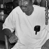
- Green Valley Pharmacy (in Green Valley Neighborhood)
- Story
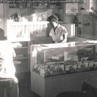
- Green Valley Pharmacy helped shape and define the Nauck community for more than six decades. The original owner of the business, Leonard Muse, was often called "Doc Muse" by friends and customers alike. Muse attended Howard University School of Pharmacy in Washington, D.C., and graduated on June 6, 1948. As one of 13 graduates in his class, he started his professional career employed by Johnson Pharmacy, located at 600 3rd Street in Southwest DC. Muse was surprised to learn that there were no pharmacies in nearby Arlington that allowed African Americans to come into their stores. Typically, Black customers had to use rear entrances and were not treated well with their medical prescriptions. A friend from Norfolk, Virginia, Waverly W. Jones, who was a classmate of his at Howard and a member of the same graduating class, suggested they go into business together and open a pharmacy in Virginia. Muse and Jones first rented a vacant grocery store at 2415 Shirlington Road and then formally purchased the property on September 14, 1955. The pharmacy was especially popular for its dine-in food counter. Breakfast, lunch, dinner, beverages, and an abundance of ice cream desserts were available. Customers of all ages could dine at the counter. From the onset, Muse felt it was very important to convince customers that his business was there to help them and unite the community. In 2011, Arlington County listed the property as a local historic district and dedicated a historic marker on the site.
- People
-
Leonard “Doc” Muse
Annie Brown - Place
- Green Valley
- Source
- A-Guide-to-the-African-American-Heritage-of-Arlington-County-Virginia.pdf, 35-36.
- Item sets
- Black Mobility Archive: Arlington, VA
- Subject of Research
- Calloway United Methodist Church (Current and Historic)
- Story
-
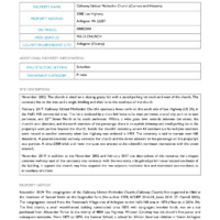
The congregation of the Calloway United Methodist Church (Calloway Church) first organized in 1866 at the residence of Samuel Smith on the Saegmuller farm (No author 1978; ACHPP 2016:18; Jones 2018: 27; Carroll 2002). The congregation moved from the Freedman’s Village area of Arlington to the Hall’s Hill area in 1870 (Maas et. al 2016: 34). The first church, a small wood-framed building constructed circa 1870 with congregant member funds, was on a site purchased from Alexander Parker in the vicinity of 4800 Lee Highway. Winston Calloway was the church’s first pastor and subsequent namesake. From 1872 to 1876, the Sumner School, a school for African American children in North Arlington County, held weekly classes in the church building. In 1888, the current site was conveyed by congregant member and church trustee, Moses Jackson, although its most long-standing structure was not constructed until 1904 (ACHPP 2016: 18). The cemetery was established during the same time with its first and last recorded burials in 1891 and 1959, respectively. The oldest graves belong to Margaret Hyson (1825-1891), an emancipated slave who worked on the Hall’s Hill plantation and the Rev. Winston Calloway (1843-1891) (Sullivan 2012; ACHPP n.d.). “The Calloway Cemetery is the oldest known church-affiliated, African American graveyard in the Hall’s Hill neighborhood and possibly in all of Arlington. This historic cemetery represents an important connection to Arlington’s undocumented African American heritage” (ACHPP n.d.); it is noted here for context with its associated church building but is recorded separately in the Virginia Cultural Resource Information System (see DHR #000-9858). The Calloway Church Cemetery became an Arlington County Historic District in 2012 and appears to be eligible for listing in the National Register of Historic Places for its association with African American Ethnic Heritage (ACHPP 2016: 18; Maas et al. 2016: 106-107).
According to the cornerstone, earliest renovations to the 1904 edifice occurred in 1940 although the extent of the building campaign is unknown.
From 1947 through 1959, Rev. John F. Monroe led Calloway. The church membership grew, and the building was improved under his pastoral leadership. John Carpenter presenting the church with new flooring and electrical fixtures. Charles Chinn and Robert Nickerson, representing Wilson Lodge #196, presented the church with the lot adjoining the church (Jones 2018: 89).
Congregant member, local architect, and Hall’s Hill community member E. Leslie Hamm was the project architect for the church’s renovation and expansion in 1979 under the pastorate of Rev. Carl Renick. The renovation nearly doubled the square footage, expanded the choir loft, and added an open bell tower, vestibule, and new classrooms (ACHPP 2016: 18). The same year as its last 1959 burial, the widening of Lee Highway caused the relocation of ten graves to Coleman Cemetery in Fairfax County (ACHPP 2016: 18; ACHPP 2012:6). More recent renovations to the building include replacement windows and a remodel of the corner tower although the overall footprint of the 1979 renovation appears intact.
For over a century, Calloway Church fulfilled roles beyond its spiritual capacity serving as a civic and social center for long-standing community organizations like the John M. Langston Citizens Association (established 1924), the John M. Langston School (established 1925), and the Hall’s Hill Volunteer Fire Department (established 1918) (Jones 2018: 58-59). During the Civil Rights Movement, Calloway Church provided student aid and hosted visitors, most notably during the Resurrection City/Poor People’s Convention (May 12 – June 24, 1968) (Jones 2018: 96, 136, 164). The church provided safe space for students to meet and prepare for integration and continued this tradition summarized in its current mission statement: “Open doors. Open hearts. Open minds.” Calloway Church is a life member of the National Association for the Advancement of Colored People, which speaks to its ongoing involvement in civil rights since the 1960s. - People
-
Alexander Parker
Margaret Hyson
Moses Jackson
Rev. Winston Calloway
Rev. John F. Monroe
E. Leslie Hamm
Rev. Carl Renick
- Place
-
5000 Lee Highway
Arlington VA 22207
- Item sets
- Black Mobility Archive: Arlington, VA
- Subject of Research
- The Hopewell Lodge No. 1700 of the Grand United Order of Odd Fellows
- Story
-
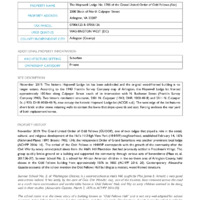
The Grand United Order of Odd Fellows (GUOOF), one of two lodges that played a role in the social, cultural, and religious development of the Hall’s Hill/High View Park (HHHVP) neighborhood, established February 14, 1876 (Richmond Planet 1897; Brooks 1902: 134); the Independent Order of Grand Samaritans was another prominent local lodge (ACHPP 2016: 16). The arrival of the Odd Fellows in HHHVP corresponds with the growth of the community after the Civil War by newly emancipated slaves from the Hall’s Hill Plantation that had previously settled in Freedman’s Village. The group quickly broke ground on a building and supported the community through various acts of benevolence (Maas et. al. 2017:36-37). Sumner School No. 2, a school for African American children in the northern area of Arlington County, held classes in the Odd Fellows building from approximately 1876 to 1885 (ACHPP 2016: 20). Contemporary Alexandria Gazette accounts of the school mention the Odd Fellows Hall building as a modest, wood-framed structure.
Arlington County land records from August 28, 1888 list Moses Jackson, George H. Hyson, Shirley Snowden, Joseph Bolden, and Horace Shelton as purchasers of one acre of land for $80 from the Bazil Hall Plantation on behalf of the Grand United Order of Odd Fellows, Hopewell Lodge No. 1700 (ACHPP 2016:15; Jones 2018:16). The 1943 Franklin Survey Company map of Arlington County identifies the Hopewell Lodge as located between the John M. Langston School and the Mt. Salvation Baptist Church at ~2020 N. Culpepper Street.
The GUOOF came to be a predominately African American group in the United States although the fraternal order was founded in England in 1798 and a few unofficial chapters had begun in place in the early 1840s. In March 1843, the African-American New York Philomathean Institute and Philadelphia Library Company and Debating Society became the first two official GUOOF lodges; each had denied acceptance by unofficial local chapters due to racial prejudice. Peter Ogden, a West Indian steward of the S.S. Patrick Henry, a British vessel, facilitated the establishment of the two lodges which set precedence for the chapters in Arlington, Va. By 1900, the GUOOF in America was the second largest African American fraternal organization with over 200,000 members and over 2,000 lodges. Its membership consisted mainly of lawyers, doctors, military officers, ministers, and other professionals (GUOOFA n.d.). Despite their Mason-like power structure, the Odd Fellows utilized Biblical content in their rituals for lodge establishment. “Many historians note the Odd Fellows as one of the most significant black mutual aid societies even at its beginning stages in the 1840’s, and the hybrid of non-denominational Christian content and a Mason-modeled organizational structure may have been why” (Barga n.d.).
- People
-
Miss Jennie E. Arnold
Geo. Ott Wunder, esq.
Moses Jackson
George H. Hyson
Shirley Snowden
Joseph Bolden
Horace Shelton
Peter Ogden - Place
-
Halls Hill/Highview Park
2000 Block of North Culpeper Street
Arlington, VA 22207
- Item sets
- Black Mobility Archive: Arlington, VA
- Subject of Research
- Mount Salvation Baptist Church
- Story
-
Reverend Cyrus Carter, originally from Port-au-Prince, Haiti, organized several Baptist churches within the African-American communities in Northern Virginia between 1866 and 1873. Rev. Carter organized the First Baptist Church of Chesterbrook, the First Baptist Church of Vienna, Mount Salvation Baptist Church (Mount Salvation) in Arlington, and Shiloh Baptist Church in McLean, VA (SBC n.d.). When Rev. Carter organized Mount Salvation circa 1872, the congregation began meeting at the residence of Brother Moses and Hattie Pelham by 1879 in what became known as “Pelham Town” (MSBC n.d.; ACHPP 2016:19); the colloquial name for the acreage near Hall’s Hill owned and occupied by the Pelham family.
Bazil and Francis Hall owned the 327-acre plantation that became the Hall’s Hill/High View Park neighborhood. To recoup losses after the Civil War, Hall eventually subdivided and sold the plantation in one-acre lots to African Americans between 1881 until his death in 1888 (ACHPP 2016:12-15). According to the history of Mount Salvation, the current one-acre site was purchased in 1884 by the trustees of the church from Bazil and Francis Hall for $80. Original church trustees included Moses Pelham Sr. Washington Jones, Bonaparte Moten, Harrison King, and Horace Shelton. Land for the cemetery was acquired in 1888, and the first permanent church was constructed in 1892 (MSBC n.d.; ACHPP 2016:19; Maas et. al. 2016: 106). Research suggests an interim one-room, wood-framed church existed between 1884 and 1892. Through circa 1885, the Independent School, an area school for African American children in Hall’s Hill/High View Park, used the building for classes when the Washington School District constructed a new Sumner School at the corner of Lee Highway and N. Culpeper Street (MSBP n.d.; Best et. al. 1995).
Reverend Cyrus Carter of Lincolnville, VA was Mount Salvation’s first officiating pastor (MSBC n.d.). Under the pastorate of Reverend Chinnor Coleman (1905-1917), the building was enlarged, and a baptismal pool installed. Rev. N.R. Richardson was pastor from 1931-1966; he and his family lived in D.C.. His assistant pastor was Rev. James E. Browne (Jones 2018:59). Under Richardson, the church had its most prolific building campaign beginning in the 1940s. Renovations in 1942 included a façade renovation and the addition of a basement, new windows and automatic bells/chimes. The two-story central bell tower was constructed in the 1950s and a new composition shingle roof was added over the original roof in 1963 (ACHPP 2016: 19; SID 2013b; ACBP 1963).
Rev. Browne was the assistant pastor of Mount Salvation, and during this period, he began to lead young adult activities. The church was a member of the Northern Virginia Baptist Association, a group of black Baptist churches. Rev. Browne made sure Mount Salvation youth were involved in the Association's youth activities, especially the annual convention. He also was an integral part of the Baptist Center, a property they owned where meetings, religious services, and summer camps were held (Jones 2018:88).
Mount Salvation played an essential role during the civil rights movement by organizing events in conjunction with Calloway Baptist Church, the Arlington branch of the National Association for the Advancement of Colored People (NAACP), and HHHVP residents (Jones 2018: 73). Rev. Browne had moved from Cherrydale to 2011 N. Culpeper and became president of the local chapter of the NAACP during this time. Rev. Browne opened his home for a local NAACP meeting that included Attorney Thurgood Marshall and Attorney Robinson where the decision was made to shift from focusing on “equalizing” African American schools and starting suit to desegregate and end Jim Crow laws (Browne in Bozeman et. al. 2004; Jones 2018:73).
The original 1892 Mount Salvation church building was demolished on July 24, 1975 to make way for a new structure approved for construction on May 13, 1974 (ACDP n.d.; Building Permit No.8760-C). Architect Charles J. Bryant, of Bryant & Bryant (Washington, D.C.) designed the new masonry and steel structure; E.L. Daniels of Arlington, VA was the contractor. The new church is associated with the historic Mount Salvation Baptist Church Cemetery (VDHR #000-9812).
- People
-
Reverend Cyrus Carter
Reverend Chinnor Coleman
Rev. N.R. Richardson
Rev. James E. Browne - Place
-
Halls Hill/Highview Park
1961 North Culpeper Street
Arlington, VA 22207
- Item sets
- Black Mobility Archive: Arlington, VA
- Subject of Research
- Miss Allen’s Store
- Story
-
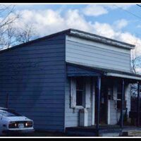
Prior to the Civil Rights Movement, African American communities were mostly autonomous and self-reliant for goods and services. Many service-oriented businesses were located within the homes of the proprietors to offset the cost of purchasing land and building a shop (ACHPP 2016: 16). The home of Washington and Rose Allen was reportedly the first home-based general store in Hall’s Hill/Highview Park, a historically African American neighborhood located south of Lee Highway (Maas et. al. 2016:60; Jones 2018:170). The store was commonly referred to as “Wash Allen’s Store” and “Mrs. Allen’s Store” after Washington Allen passed (Carroll 2002:21; Jones 2018:170). Arlington Directories from 1955 to 1964 list Rose H. Allen as resident of 1821 N. Columbus Street as well as the “Allen & Davis Grocery” (Hill 1955, 1957, 1959, 1961, and 1964).
According to the Arlington County Building Card for 1821 N. Columbus Street, the residence, noted as a “concrete block dwelling,” was owned and occupied by Washington and Rose Allen in 1935. The 1935 building card indicates a variety of maintenance work was performed throughout the 1960s and 1970s to include: a replacement roof on June 17, 1963 (Permit #2105); repairs to a garage and a barn demolition on March 31, 1964 (Permit #23800); new wooden siding and the replacement of rotting wood on October 1, 1965 (Permit #25385); replacement roof on November 1, 1967 (Permit #8391); replacement aluminum siding on three exterior walls with pre-cast stone on the front on June 9, 1970 (Permit #11095); and re-roofing of the front slope only on November 11, 1977 (Permit #5873).
Rose Allen owned two lots in the High View Park subdivision, the west side of Lot 8 (1825 N. Columbus St.) and Lot 9 of the High View Park subdivision, that had west and east access to N. Columbus and N. Cameron Streets respectively. She began selling off portions of her property in the mid-1960s. She demolished the barn behind her home in 1964. Everett and Irene Easter purchased the west section of Lot 8 from Allen (Deed Book 1653/352) and constructed a residence according to Building Permit #37036 dated August 11, 1967. The Easter family sold the property to Alfred W. & Jalorce M. Clark the following year (Deed Book 1665/532).
In 1968, Allen subdivided Lot 9 into west and east sections; Lot 9A contained the original dwelling and Lot 9B included the east 100-feet of Lot 9 that faces N. Cameron (ACBP #; DB 1674/367). James E. & Carole J. Taylor purchased Lot 9B from Rose Allen (Deed Book 1677/524) and constructed the home (Building Permit #37255 on 6/7/1968).
Based on the Arlington County Property Appraisers records, the Hall’s residence (Lot 9A) was conveyed to family member Elizabeth Samuel Long on May 6, 1987 (Deed Book W118/0028) in Hall’s will. The historic home appears to have been razed circa 2001 as only the land was sold in 2001(ACREA 2001). The extant residence was constructed circa 2002.
As a demolished resource, the former Miss Allen’s Store is not eligible for listing in the National Register of Historic Places (NRHP). - People
- Washington and Rose Allen
- Place
-
Mrs. Allen's Store, Halls Hill Neighborhood
1821 North Columbus Street
Arlington, VA 22207
- Item sets
- Black Mobility Archive: Arlington, VA
- Subject of Research
- Freedman's Village
- Story
-
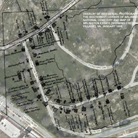
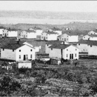
When President Lincoln passed legislation freeing all the slaves in the District of Columbia on April 16, 1862, large numbers of emancipated and fugitive slaves from Virginia and Maryland fled to the city for protection. Facing a humanitarian crisis, contraband hospitals and camps were established, but overcrowding and poor living conditions led to rampant diseases that contributed to high mortality rates. The issuance of the Emancipation Proclamation on January 1, 1863, led to an additional influx of African Americans and prompted military officials to establish Freedman's Village.
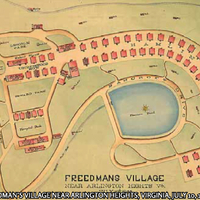
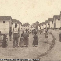
On May 5, 1863, Lieutenant Colonel Elias M. Greene, and Danforth B. Nichols, American Missionary Association, selected Arlington Plantation as the site for a model community for emancipated and fugitive slaves. The location satisfied the government's desire to remove the former slaves from the city and served as a symbol to house the freedpersons on Robert E. Lee's property. By June 1863, 100 former slaves settled on "a fine plateau on the top of a hill on the Arlington Estate." Formally dedicated on December 3, 1863, the village consisted of approximately 50 frame dwellings each divided down the middle for occupancy by two families, a hospital, a home for the indigent, a school, and a chapel.
The Freedman's Bureau categorized residents into three classifications: 1) dependents (well and sick) who were unable to work; 2) residents in government employment; and 3) residents who received rations and liens on crops. The objective of the camp was to provide protection, education, instruction, and employment to residents. Men living at the village were often expected to work as military laborers or on government farms. Women labored in tailor shops sewing clothing and other goods. Over a three-month span, the industrial school produced 1,000 garments per month. The government assumed that the village would serve only as temporary housing, but many residents stayed and created a semi-permanent settlement that lasted until the turn of the twentieth century.
The population of the village greatly fluctuated with estimates suggesting over 1,000 residents at first. On one day alone, March 22, 1864, 408 survivors from the failed freedmen colony established on Ile a Vache, a small island off the cost of Haiti, arrived at Freedman's Village. In July 1867, 837 inhabitants lived at Freedman's Village: 619 occupying tenements (330 of whom were dependent), 83 residing in the home for the indigent, 35 staying at the hospital, and 100 in the vicinity of the village proper.
Living conditions and the treatment of residents also widely varied. In December 1864, an investigation into the treatment of residents yielded troubling results, but the investigation spurred improvements.
Within the short space of three weeks thirty of these houses, forming one hundred and twenty distinct dwellings have been nearly completed. The inmates of the old tents have been removed to these comfortable dwellings, and the whole camp wears a different aspect.
'The Home' has been opened; and the old and feeble have been comfortably provided for. The hospital was also opened with thirty-two beds within ten days after our first visit. This has been a great relief; and a number who [were] suffering in misery have passed away their last hours in comparative comfort. —Special Inspectors at Arlington Heights, 1864
Some residents resented the policies of both the Army and then the Bureau of Refugees, Freedmen, and Abandoned Lands. Tensions over rent and rent collection strained relations. In 1866, the Freedmen's Bureau issued regulations that all inhabitants who were remotely capable enter the workforce and be required to pay rent in advance. Fifty-two heads of family were relatively successful and cultivated 280 acres of land on the estate. Renters of land included William Butler, Thornton Gray, William Rowe, and Austin Syphax. Dependent households with a lack of job opportunities, however, suffered under the new regulations. A number of residents that constructed dwellings outside of the village proper were evicted from their homes.
Closing of Freedman’s Village
In 1868, government officials attempted to close Freedman's Village permanently, but the residents successfully resisted. The government then moved the inhabitants of the Abbott Hospital and Home for the Indigent to Freedmen's Hospital in Washington, D.C. Residents of the village were allowed to purchase their dwellings and rent approximately 600 acres of land (in approximately 10-acre lots).
[In 1868,] the buildings were generally of frame; in size about 28 by 24 feet; one and a half stories in height, with 8 rooms each. They had shingled roofs, brick flues, and were sheathed on the outside with rough weather-board siding. They were not plastered or [sealed] inside. The price paid was from $35 to $50 for each building. —Military Reservation of Fort Myer and Arlington, VA., 1888
The residents continued to live on the property for another 30 years and invested in the community. They believed that they would possess a claim to Arlington as implied by the government. Between 1868 and 1888, new homes were constructed, improvements were made to the purchased dwellings, and a brick church was built.
Most of the purchasers have improved the premises by reflooring, by reroofing, by plastering or ceiling the rooms, and in several cases such improvements have been equal to twice or thrice the original cost of the building. [The buildings]...are occupied by the builders, or by those who purchased from the builders. Io these have been added small outbuildings, such as stables, sheds, chicken-houses, etc. —Military Reservation of Fort Myer and Arlington, VA., 1888
In 1888, the village consisted of 124 dwellings, 3 shops, 2 churches, 1 school, and 170 families totaling a population of 763. There were two justices of the peace, one constable, and two special policemen. Most of the adult males voted and paid taxes (personal property, poll, school, and road taxes). Over 50 percent of the families who lived at the village had resided on the property for at least 15 years. Development pressure and other factors led to renewed efforts to close Freedman's Village. John B. Syphax requested that the Secretary of War compensate each homeowner $350 for the loss of property. - People
-
William Butler
Thornton Gray
William Rowe
Austin Syphax
John B. Syphax
- Place
-
Green Heights (past)
Arlington National Cemetery (current) - Source
- A-Guide-to-the-African-American-Heritage-of-Arlington-County-Virginia.pdf, 5-10.
- Item sets
- Black Mobility Archive: Arlington, VA
- Subject of Research
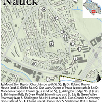
- Development of Nauck Neighborhood
- Story
-
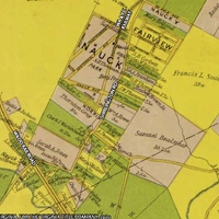
John D. Nauck purchased and subdivided a large section of Nauck. Born in Germany in 1846, Nauck immigrated to the United States ca. 1854. During the Civil War, he served in the Confederate Army as a Private. After the war, he lived in Washington, D.C., worked as an upholsterer, and married Martha Ann Webb in 1872. They purchased 46 acres from Rudolph Buckley and Emma Jones on November 5, 1874, and 23 acres from John and Mary Winsatt on December 21, 1875. The Naucks subdivided the land and lived on a parcel with their two children. Thomas N. Carter completed a survey entitled the "Map of the Town of Nauck, Alexandria County, Virginia (formerly known as Nauckville and Convalescent Camp)" on July 1, 1876, but it was not recorded until November 16, 1885. The community continued to be known by African Americans as "Nauckville" into the late-nineteenth century as evidenced by weekly articles in the Washington Bee.
[John D.] Nauck also held county positions such as Justice of the Peace between 1890 and 1891. Between 1880 and 1900, Nauck completed land sales primarily to African Americans, possibly even those leaving Freedman's Village. The Washington Post reported that Nauck had sold considerable property to African Americans in Alexandria County. Purchasers had paid him per an installment plan. Nauck fled the County when an African American resident of Nauck in arrears reportedly assaulted and threatened him and his family when he tried to evict him from their property in 1891. John Nauck died on February 2, 1925, in Washington, D.C. He is buried in the Confederate soldiers section of Arlington National Cemetery.
The subdivision of Nauck slowly grew in the late nineteenth century. The availability of land coupled with a prominent group of settled African American owners, establishment of the A.M.E. Zion Church, success of the Kemper School, and opening of a railroad station on the Richmond and Danville Railroad (later known as the Washington & Old Dominion Railroad) made it a desirable location.
The Nauckville Post-Office, Nauckville is about two miles from the Arlington Post-Office, and with a Depot Station, School-house, and Church, to the population of one hundred fifty citizens are entitled to a post-office of their town.
—Washington Bee, June 13, 1896
The neighborhood welcomed an influx of African Americans forced to vacate Freedman's Village. Between 1880 and 1900, the majority of Nauck residents served as farm laborers or brick layers. Additional employment opportunities were made possible with the opening of Nauck Station on the Fort Myer line of the Washington, Alexandria, and Falls Church Railway at the turn of the twentieth century. The electric railway allowed residents of Nauck to more easily commute to Rosslyn, Washington, D.C., and other nearby places of employment.
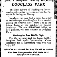
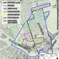
Development of the neighborhood continued but African American settlement to Nauck, Alexandria County, and Virginia would soon be depressed with the adoption of the Virginia Constitution in 1902. The State Constitution discriminated against blacks in numerous ways including disenfranchisement, segregation, and fewer public appropriations. By 1904, the number of African Americans who voted in Virginia dropped from 147,000 to less than 10,000. The Nauck community, however, continued to grow due to local residents who further subdivided property (such as the heirs of Thornton and Selina Gray, William Rowe, Henry Wallace, and Mary Norris) or the creation of adjoining subdivisions such as Fairview, West Nauck, Douglass Park, and Nauck Heights. All or significant sections of these subdivisions are considered as part of the present Nauck community. Nevertheless, Nauck still had a significant percentage of vacant lots by World War II.
Nauck's churches, schools, and lodges provided social, cultural, and religious enrichment. Jim Crow laws led to the establishment of many African American-owned businesses, particularly along present-day South Shirlington Road. By the mid-twentieth century, Nauck businesses serviced the basic needs of its residents and beyond. Cecilia Gertzikoff and Etta Bregman opened a small grocery store named Green Valley Market. Ralph Delaware Collins started the Friendly Cab Company. James Elwood Chinn opened Chinn Funeral Home. Restaurants, auto repair stores, television repair stores, beauty and barber shops, a pharmacy, and other stores created a vibrant community. Similar to Hall's Hill, some residents operated small businesses from their homes, but these stores were closed after the end of segregation. - People
-
Thornton and Selina Gray’s heirs
William Rowe’s heirs
Henry Wallace’s heirs
Mary Norris’s heirs
Cecilia Gertzikoff and Etta Bregman
Ralph Delaware Collins
James Elwood Chinn - Place
-
Fairview
West Nauck
Douglass Park
Nauck Heights
Green Valley Market
Friendly Cab Company
Chinn Funeral Home - Source
- A-Guide-to-the-African-American-Heritage-of-Arlington-County-Virginia.pdf, 25-27.
- Item sets
- Black Mobility Archive: Arlington, VA
- Subject of Research
- The Bottom: An African American Enclave Rediscovered
- Source
-
Jessica Kaplan
Arlington Historical Society
- Item sets
- Black Mobility Archive: Arlington, VA
- Media
 2018-2-Bottom.pdf