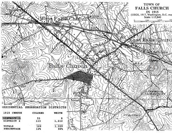
The Town of Falls Church in 1915
Item
-
Title
-
The Town of Falls Church in 1915
-
Repository
-
Mary Riley Styles Public Library - Falls Church History Room
-
Date Created
-
1917
-
Creator
-
United States Geological Survey
-
Description
-
A 1917 USGS map of the town with residential segregation districts data added. District one highlighted in black is the local district within which all sales could be made on property by Black residents. This primarily comprised of the Tinner Hill community and its surrounding residents. If the law for segregation districts were upheld according to the law this very likely would have created a ghettoizing effect on this region of Falls Church. This map also demonstrates the population per district demonstrating that district one was primarily comprised of Black residents.
While the law was made unconstitutional by Buchanan v. Warley in 1917 it stayed on the book, and the segregation district was still "in effect" though nullified. This exemplifies displacement in place, and marked the region, as prior to this law the location was disproportionately Black land/homeowners while the rest were interspersed at much lower concentrations. This furthered their separation from white land/homeowners after the retrocession of 1887 by denoting their segregation plan on a map even if it was not legally enforceable.
-
Research Themes
-
Falls Church
Tinner Hill
Displacement in Place
Slow Violence
Segregation
Segregation districts
Segregation Ordinance of 1915
-
Type
-
Map
-
Bibliographic Citation
-
United States Geological Survey. “The Town of Falls Church in 1915.” United States Geological Survey, 1915. Falls Church History Room. Mary Riley Styles Public Library. https://history.fallschurchva.gov/Presto/content/Detail.aspx?q=c2VncmVnYXRpb24=&ctID=N2E4ODNjMDUtMjY5My00MjRlLWE1YmQtNTRjZjU2NWZhYzlm&rID=MjY5&qcf=&ph=VHJ1ZQ==&bckToL=VHJ1ZQ==&.
 THE TINNER HILL HISTORIC & CULTURAL DISTRICT (AMENDMENT TO THE COMPREHENSIVE PLAN)